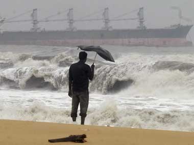
The storm hit the Andaman and Nicobar Islands with wind speed of over 110 km an hour Sunday, and lay centred about 1,180 km south-east of Gopalpur, off Odisha coast, officials said.
It would intensify further gradually into a very severe cyclonic storm and move west-north-westwards and cross Andhra Pradesh coast between Machilipatnam and Kalingapatnam near Kakinada around Nov 28 noon, they added.
The wind speed could be 180 to 200 km an hour during the land fall. Although Odisha does not see major impact at this point, Bhubaneswar Met Office has asked the state government to take adequate measures against standing crops in southern part of the state.
It has asked two state ports at Gopalpur and Paradip to keep hoisted distance warning signals and advised fishermen who are out at deep sea to return to safer places, S.C. Sahu, director of Bhubaneswar Meteorological Centre said.
"We are keeping a close watch on the cyclone. We may issue necessary alerts to all coastal districts as and when required," state relief commissioner P.K. Mohapatra said.
"We won't have any problem from wind point of view. There may be some rainfall. Rainfall for one day is ok because it may dry up. If it continues for three days, it may affect standing crops.
The latest warning has triggered fear among the coastal residents as the Bay of Bengal has already witnessed two cyclones since October.
Cyclone Helen hit the coast Friday forcing authorities to evacuate thousands of people in Andhra Pradesh. It killed six people and caused extensive damage to standing crops in that state.
Helen hit the coast weeks after a severe tropical cyclone Phailin in the Bay of Bengal devastated lives and damaged properties in more than 17 districts in Odisha after making landfall Oct 12 night near Gopalpur in the state's Ganjam district.
Phailin also caused extensive damage in Andhra Pradesh.


Comments
Add new comment